 https://amazondamsnetwork.org/wp-content/uploads/2022/02/simone_paper_image.jpg
1310
2111
Sharlynn Sweeney
https://amazondamsnetwork.org/wp-content/uploads/2021/02/ADN__logo_100pxvert.jpg
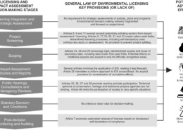
Sharlynn Sweeney2022-02-15 17:04:312022-02-15 17:07:00New journal article on the far-reaching implications of potentially rolling-back Environmental Licensing and Impact Assessment in Brazil
https://amazondamsnetwork.org/wp-content/uploads/2022/02/simone_paper_image.jpg
1310
2111
Sharlynn Sweeney
https://amazondamsnetwork.org/wp-content/uploads/2021/02/ADN__logo_100pxvert.jpg
Sharlynn Sweeney2022-02-15 17:04:312022-02-15 17:07:00New journal article on the far-reaching implications of potentially rolling-back Environmental Licensing and Impact Assessment in Brazil https://amazondamsnetwork.org/wp-content/uploads/2022/02/jones_jobs_pic.jpg
559
1141
Sharlynn Sweeney
https://amazondamsnetwork.org/wp-content/uploads/2021/02/ADN__logo_100pxvert.jpg
Sharlynn Sweeney2022-02-15 16:42:362022-02-15 16:48:52Two Postdoctoral Research Fellow positions at U. of Stirling: develop decision-support tools to forecast, mitigate, and resolve conflicts of hydropower dams
https://amazondamsnetwork.org/wp-content/uploads/2022/02/jones_jobs_pic.jpg
559
1141
Sharlynn Sweeney
https://amazondamsnetwork.org/wp-content/uploads/2021/02/ADN__logo_100pxvert.jpg
Sharlynn Sweeney2022-02-15 16:42:362022-02-15 16:48:52Two Postdoctoral Research Fellow positions at U. of Stirling: develop decision-support tools to forecast, mitigate, and resolve conflicts of hydropower dams https://amazondamsnetwork.org/wp-content/uploads/2021/12/Dec13_cover.jpg
900
691
Sharlynn Sweeney
https://amazondamsnetwork.org/wp-content/uploads/2021/02/ADN__logo_100pxvert.jpg
Sharlynn Sweeney2021-12-13 21:58:262021-12-13 21:58:26New e-book: Balancing Hydropower and Freshwater Environments in the Global South
https://amazondamsnetwork.org/wp-content/uploads/2021/12/Dec13_cover.jpg
900
691
Sharlynn Sweeney
https://amazondamsnetwork.org/wp-content/uploads/2021/02/ADN__logo_100pxvert.jpg
Sharlynn Sweeney2021-12-13 21:58:262021-12-13 21:58:26New e-book: Balancing Hydropower and Freshwater Environments in the Global South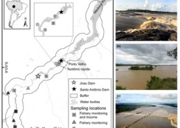 https://amazondamsnetwork.org/wp-content/uploads/2021/12/dec1_post.jpg
414
512
Sharlynn Sweeney
https://amazondamsnetwork.org/wp-content/uploads/2021/02/ADN__logo_100pxvert.jpg
Sharlynn Sweeney2021-11-22 22:04:262021-12-13 22:05:08New paper: Functional responses of fisheries to hydropower dams in the Amazonian Floodplain of the Madeira River
https://amazondamsnetwork.org/wp-content/uploads/2021/12/dec1_post.jpg
414
512
Sharlynn Sweeney
https://amazondamsnetwork.org/wp-content/uploads/2021/02/ADN__logo_100pxvert.jpg
Sharlynn Sweeney2021-11-22 22:04:262021-12-13 22:05:08New paper: Functional responses of fisheries to hydropower dams in the Amazonian Floodplain of the Madeira River https://amazondamsnetwork.org/wp-content/uploads/2021/10/paper-image_oct19post.jpg
491
692
Sharlynn Sweeney
https://amazondamsnetwork.org/wp-content/uploads/2021/02/ADN__logo_100pxvert.jpg
Sharlynn Sweeney2021-10-19 21:25:582021-10-19 21:26:25Climate change threatens hydropower energy security in the Amazon basin
https://amazondamsnetwork.org/wp-content/uploads/2021/10/paper-image_oct19post.jpg
491
692
Sharlynn Sweeney
https://amazondamsnetwork.org/wp-content/uploads/2021/02/ADN__logo_100pxvert.jpg
Sharlynn Sweeney2021-10-19 21:25:582021-10-19 21:26:25Climate change threatens hydropower energy security in the Amazon basin https://amazondamsnetwork.org/wp-content/uploads/2021/08/aug19_video_midi.jpg
438
782
Sharlynn Sweeney
https://amazondamsnetwork.org/wp-content/uploads/2021/02/ADN__logo_100pxvert.jpg
Sharlynn Sweeney2021-08-19 17:24:562021-08-19 17:24:56The impacts of hydroelectric dams on Amazonian artisanal fisheries from the perspective of socio-ecological systems
https://amazondamsnetwork.org/wp-content/uploads/2021/08/aug19_video_midi.jpg
438
782
Sharlynn Sweeney
https://amazondamsnetwork.org/wp-content/uploads/2021/02/ADN__logo_100pxvert.jpg
Sharlynn Sweeney2021-08-19 17:24:562021-08-19 17:24:56The impacts of hydroelectric dams on Amazonian artisanal fisheries from the perspective of socio-ecological systems https://amazondamsnetwork.org/wp-content/uploads/2021/08/bookreview_aug12_2.jpg
791
697
Sharlynn Sweeney
https://amazondamsnetwork.org/wp-content/uploads/2021/02/ADN__logo_100pxvert.jpg
Sharlynn Sweeney2021-08-12 22:12:382021-08-12 22:12:38Ebook: Regional Development in the Amazon: Infrastructure, Human Capital, Income and Work
https://amazondamsnetwork.org/wp-content/uploads/2021/08/bookreview_aug12_2.jpg
791
697
Sharlynn Sweeney
https://amazondamsnetwork.org/wp-content/uploads/2021/02/ADN__logo_100pxvert.jpg
Sharlynn Sweeney2021-08-12 22:12:382021-08-12 22:12:38Ebook: Regional Development in the Amazon: Infrastructure, Human Capital, Income and Work https://amazondamsnetwork.org/wp-content/uploads/2021/08/bookreview_aug12.jpg
584
656
Sharlynn Sweeney
https://amazondamsnetwork.org/wp-content/uploads/2021/02/ADN__logo_100pxvert.jpg
Sharlynn Sweeney2021-08-12 21:58:492021-08-12 22:14:21Ebook: Mining Dams in the Amazon: Tailings and Associated Risks in Oriximiná
https://amazondamsnetwork.org/wp-content/uploads/2021/08/bookreview_aug12.jpg
584
656
Sharlynn Sweeney
https://amazondamsnetwork.org/wp-content/uploads/2021/02/ADN__logo_100pxvert.jpg
Sharlynn Sweeney2021-08-12 21:58:492021-08-12 22:14:21Ebook: Mining Dams in the Amazon: Tailings and Associated Risks in Oriximiná https://amazondamsnetwork.org/wp-content/uploads/2021/08/ebook_aug4post.jpg
746
559
Sharlynn Sweeney
https://amazondamsnetwork.org/wp-content/uploads/2021/02/ADN__logo_100pxvert.jpg
Sharlynn Sweeney2021-08-05 00:09:152021-08-12 22:15:49Ebook: Hydroelectric Developments: Migration, Resettlements, Social Participation and Inclusive Community Development
https://amazondamsnetwork.org/wp-content/uploads/2021/08/ebook_aug4post.jpg
746
559
Sharlynn Sweeney
https://amazondamsnetwork.org/wp-content/uploads/2021/02/ADN__logo_100pxvert.jpg
Sharlynn Sweeney2021-08-05 00:09:152021-08-12 22:15:49Ebook: Hydroelectric Developments: Migration, Resettlements, Social Participation and Inclusive Community Development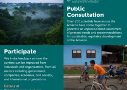 https://amazondamsnetwork.org/wp-content/uploads/2021/08/SPA-Public-Consultation-Facebook.jpg
788
940
Sharlynn Sweeney
https://amazondamsnetwork.org/wp-content/uploads/2021/02/ADN__logo_100pxvert.jpg
Sharlynn Sweeney2021-08-04 23:51:582021-08-04 23:51:59Over 200 scientists from the region have united to form the Science Panel for the Amazon (SPA)
https://amazondamsnetwork.org/wp-content/uploads/2021/08/SPA-Public-Consultation-Facebook.jpg
788
940
Sharlynn Sweeney
https://amazondamsnetwork.org/wp-content/uploads/2021/02/ADN__logo_100pxvert.jpg
Sharlynn Sweeney2021-08-04 23:51:582021-08-04 23:51:59Over 200 scientists from the region have united to form the Science Panel for the Amazon (SPA) https://amazondamsnetwork.org/wp-content/uploads/2021/03/ebook3.jpg
267
528
Sharlynn Sweeney
https://amazondamsnetwork.org/wp-content/uploads/2021/02/ADN__logo_100pxvert.jpg
Sharlynn Sweeney2021-07-29 00:38:102021-07-29 00:38:10Evaluation Of Dengue cases in the municipality Of Estreito (Ma), city under the influence of the Estreito Hydroelectric Plant
https://amazondamsnetwork.org/wp-content/uploads/2021/03/ebook3.jpg
267
528
Sharlynn Sweeney
https://amazondamsnetwork.org/wp-content/uploads/2021/02/ADN__logo_100pxvert.jpg
Sharlynn Sweeney2021-07-29 00:38:102021-07-29 00:38:10Evaluation Of Dengue cases in the municipality Of Estreito (Ma), city under the influence of the Estreito Hydroelectric Plant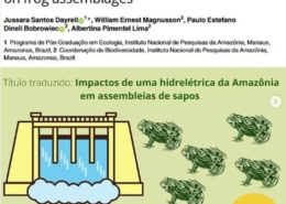 https://amazondamsnetwork.org/wp-content/uploads/2021/07/frog_paper.jpg
747
748
Sharlynn Sweeney
https://amazondamsnetwork.org/wp-content/uploads/2021/02/ADN__logo_100pxvert.jpg
Sharlynn Sweeney2021-07-05 22:18:572021-07-05 22:18:57New paper: Impacts of an Amazonian hydroelectric dam on frog assemblages
https://amazondamsnetwork.org/wp-content/uploads/2021/07/frog_paper.jpg
747
748
Sharlynn Sweeney
https://amazondamsnetwork.org/wp-content/uploads/2021/02/ADN__logo_100pxvert.jpg
Sharlynn Sweeney2021-07-05 22:18:572021-07-05 22:18:57New paper: Impacts of an Amazonian hydroelectric dam on frog assemblages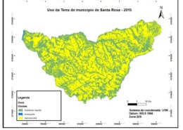 https://amazondamsnetwork.org/wp-content/uploads/2021/07/adn_chapter414.jpg
771
902
Sharlynn Sweeney
https://amazondamsnetwork.org/wp-content/uploads/2021/02/ADN__logo_100pxvert.jpg
Sharlynn Sweeney2021-07-05 22:01:392021-07-05 22:01:39ANALYSIS OF LAND USE AND LOSS OF BIODIVERSITY IN THE MUNICIPALITY OF SANTA ROSA DO TOCANTINS, TOCANTINS STATE, BRAZIL
https://amazondamsnetwork.org/wp-content/uploads/2021/07/adn_chapter414.jpg
771
902
Sharlynn Sweeney
https://amazondamsnetwork.org/wp-content/uploads/2021/02/ADN__logo_100pxvert.jpg
Sharlynn Sweeney2021-07-05 22:01:392021-07-05 22:01:39ANALYSIS OF LAND USE AND LOSS OF BIODIVERSITY IN THE MUNICIPALITY OF SANTA ROSA DO TOCANTINS, TOCANTINS STATE, BRAZIL https://amazondamsnetwork.org/wp-content/uploads/2021/02/ebook.jpg
474
359
Sharlynn Sweeney
https://amazondamsnetwork.org/wp-content/uploads/2021/02/ADN__logo_100pxvert.jpg
Sharlynn Sweeney2021-07-05 21:56:172021-07-05 21:56:17VARIATION IN ENVIRONMENTAL IMPACTS FROM TRANSMISSION LINES ACROSS STATES IN THE BRAZILIAN AMAZON
https://amazondamsnetwork.org/wp-content/uploads/2021/02/ebook.jpg
474
359
Sharlynn Sweeney
https://amazondamsnetwork.org/wp-content/uploads/2021/02/ADN__logo_100pxvert.jpg
Sharlynn Sweeney2021-07-05 21:56:172021-07-05 21:56:17VARIATION IN ENVIRONMENTAL IMPACTS FROM TRANSMISSION LINES ACROSS STATES IN THE BRAZILIAN AMAZON https://amazondamsnetwork.org/wp-content/uploads/2021/06/ebook_blackout.jpg
647
875
Sharlynn Sweeney
https://amazondamsnetwork.org/wp-content/uploads/2021/02/ADN__logo_100pxvert.jpg
Sharlynn Sweeney2021-06-17 20:53:262021-06-17 20:53:41eBook: FROM BLACKOUT TO ERASED: ESSAYS ON THE AMAPA ENERGY QUESTION
https://amazondamsnetwork.org/wp-content/uploads/2021/06/ebook_blackout.jpg
647
875
Sharlynn Sweeney
https://amazondamsnetwork.org/wp-content/uploads/2021/02/ADN__logo_100pxvert.jpg
Sharlynn Sweeney2021-06-17 20:53:262021-06-17 20:53:41eBook: FROM BLACKOUT TO ERASED: ESSAYS ON THE AMAPA ENERGY QUESTION https://amazondamsnetwork.org/wp-content/uploads/2021/06/412.jpg
675
709
Sharlynn Sweeney
https://amazondamsnetwork.org/wp-content/uploads/2021/02/ADN__logo_100pxvert.jpg
Sharlynn Sweeney2021-06-17 20:46:392021-06-17 21:23:46Chapter 4.1.2: ENVIRONMENTAL AND SOCIAL IMPACTS OF HPP’S IN THE LOWER CIRCUIT OF THE ECONOMY
https://amazondamsnetwork.org/wp-content/uploads/2021/06/412.jpg
675
709
Sharlynn Sweeney
https://amazondamsnetwork.org/wp-content/uploads/2021/02/ADN__logo_100pxvert.jpg
Sharlynn Sweeney2021-06-17 20:46:392021-06-17 21:23:46Chapter 4.1.2: ENVIRONMENTAL AND SOCIAL IMPACTS OF HPP’S IN THE LOWER CIRCUIT OF THE ECONOMY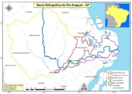 https://amazondamsnetwork.org/wp-content/uploads/2021/06/411.jpg
451
638
Sharlynn Sweeney
https://amazondamsnetwork.org/wp-content/uploads/2021/02/ADN__logo_100pxvert.jpg
Sharlynn Sweeney2021-06-16 23:40:192021-06-16 23:42:55Chapter 4.1 – Impacts associated with hydroelectric plants in the Araguari River Basin – BHRA, Amapá
https://amazondamsnetwork.org/wp-content/uploads/2021/03/ebook3.jpg
267
528
Sharlynn Sweeney
https://amazondamsnetwork.org/wp-content/uploads/2021/02/ADN__logo_100pxvert.jpg
Sharlynn Sweeney2021-06-03 20:58:042021-06-03 20:58:04Chapter 3.4: Damming and changes to fish and fisheries
https://amazondamsnetwork.org/wp-content/uploads/2021/06/411.jpg
451
638
Sharlynn Sweeney
https://amazondamsnetwork.org/wp-content/uploads/2021/02/ADN__logo_100pxvert.jpg
Sharlynn Sweeney2021-06-16 23:40:192021-06-16 23:42:55Chapter 4.1 – Impacts associated with hydroelectric plants in the Araguari River Basin – BHRA, Amapá
https://amazondamsnetwork.org/wp-content/uploads/2021/03/ebook3.jpg
267
528
Sharlynn Sweeney
https://amazondamsnetwork.org/wp-content/uploads/2021/02/ADN__logo_100pxvert.jpg
Sharlynn Sweeney2021-06-03 20:58:042021-06-03 20:58:04Chapter 3.4: Damming and changes to fish and fisheries https://amazondamsnetwork.org/wp-content/uploads/2021/05/swanson_imagery_paper.jpg
1173
1650
Sharlynn Sweeney
https://amazondamsnetwork.org/wp-content/uploads/2021/02/ADN__logo_100pxvert.jpg
Sharlynn Sweeney2021-05-28 22:32:572021-05-28 22:32:57New paper on land cover change and dams on the land–water interface of the Tocantins River
https://amazondamsnetwork.org/wp-content/uploads/2021/03/ebook3.jpg
267
528
Sharlynn Sweeney
https://amazondamsnetwork.org/wp-content/uploads/2021/02/ADN__logo_100pxvert.jpg
Sharlynn Sweeney2021-05-28 22:21:402021-05-28 22:21:40Chapter 3.3 – Climate change impacts on Native American water resources: engaging in culture-based solutions
https://amazondamsnetwork.org/wp-content/uploads/2021/05/swanson_imagery_paper.jpg
1173
1650
Sharlynn Sweeney
https://amazondamsnetwork.org/wp-content/uploads/2021/02/ADN__logo_100pxvert.jpg
Sharlynn Sweeney2021-05-28 22:32:572021-05-28 22:32:57New paper on land cover change and dams on the land–water interface of the Tocantins River
https://amazondamsnetwork.org/wp-content/uploads/2021/03/ebook3.jpg
267
528
Sharlynn Sweeney
https://amazondamsnetwork.org/wp-content/uploads/2021/02/ADN__logo_100pxvert.jpg
Sharlynn Sweeney2021-05-28 22:21:402021-05-28 22:21:40Chapter 3.3 – Climate change impacts on Native American water resources: engaging in culture-based solutions https://amazondamsnetwork.org/wp-content/uploads/2021/05/paper_may11_fig.jpg
732
1196
Sharlynn Sweeney
https://amazondamsnetwork.org/wp-content/uploads/2021/02/ADN__logo_100pxvert.jpg
Sharlynn Sweeney2021-05-11 22:25:322021-05-11 22:27:01New paper: “Stakeholder Perceptions on the Governance of Fisheries Systems Transformed by Hydroelectric Dam Development in the Madeira River, Brazil”
https://amazondamsnetwork.org/wp-content/uploads/2021/03/ebook3.jpg
267
528
Sharlynn Sweeney
https://amazondamsnetwork.org/wp-content/uploads/2021/02/ADN__logo_100pxvert.jpg
Sharlynn Sweeney2021-05-11 22:14:272021-05-11 22:14:39Forgetting people in energy development of Belo Monte and other dams
https://amazondamsnetwork.org/wp-content/uploads/2021/03/ebook3.jpg
267
528
Sharlynn Sweeney
https://amazondamsnetwork.org/wp-content/uploads/2021/02/ADN__logo_100pxvert.jpg
Sharlynn Sweeney2021-05-11 22:09:042021-05-11 22:09:04Hydroelectric dams and Amazonian traditional peoples: elements for a preliminary and introductory prognosis
https://amazondamsnetwork.org/wp-content/uploads/2021/05/paper_may11_fig.jpg
732
1196
Sharlynn Sweeney
https://amazondamsnetwork.org/wp-content/uploads/2021/02/ADN__logo_100pxvert.jpg
Sharlynn Sweeney2021-05-11 22:25:322021-05-11 22:27:01New paper: “Stakeholder Perceptions on the Governance of Fisheries Systems Transformed by Hydroelectric Dam Development in the Madeira River, Brazil”
https://amazondamsnetwork.org/wp-content/uploads/2021/03/ebook3.jpg
267
528
Sharlynn Sweeney
https://amazondamsnetwork.org/wp-content/uploads/2021/02/ADN__logo_100pxvert.jpg
Sharlynn Sweeney2021-05-11 22:14:272021-05-11 22:14:39Forgetting people in energy development of Belo Monte and other dams
https://amazondamsnetwork.org/wp-content/uploads/2021/03/ebook3.jpg
267
528
Sharlynn Sweeney
https://amazondamsnetwork.org/wp-content/uploads/2021/02/ADN__logo_100pxvert.jpg
Sharlynn Sweeney2021-05-11 22:09:042021-05-11 22:09:04Hydroelectric dams and Amazonian traditional peoples: elements for a preliminary and introductory prognosis https://amazondamsnetwork.org/wp-content/uploads/2021/04/nature_dampaper_figure.jpg
476
607
Sharlynn Sweeney
https://amazondamsnetwork.org/wp-content/uploads/2021/02/ADN__logo_100pxvert.jpg
Sharlynn Sweeney2021-04-26 15:15:382021-05-11 22:27:15New paper on rethinking dams / in-stream turbines
https://amazondamsnetwork.org/wp-content/uploads/2021/03/ebook3.jpg
267
528
Sharlynn Sweeney
https://amazondamsnetwork.org/wp-content/uploads/2021/02/ADN__logo_100pxvert.jpg
Sharlynn Sweeney2021-04-08 16:56:472021-05-11 15:01:04Chapter 2.3: River values, uses and decision-making
https://amazondamsnetwork.org/wp-content/uploads/2021/03/ebook3.jpg
267
528
Sharlynn Sweeney
https://amazondamsnetwork.org/wp-content/uploads/2021/02/ADN__logo_100pxvert.jpg
Sharlynn Sweeney2021-03-31 02:34:482021-05-11 15:01:20A river unites indigenous peoples of the Americas: a cultural exchange on the legacy of the impacts of hydroelectric dams on the Colorado and Tocantins rivers
https://amazondamsnetwork.org/wp-content/uploads/2021/03/ebook3.jpg
267
528
Sharlynn Sweeney
https://amazondamsnetwork.org/wp-content/uploads/2021/02/ADN__logo_100pxvert.jpg
Sharlynn Sweeney2021-03-31 02:32:352021-05-11 15:01:37Learning from the other: perceptions and exchanges of knowledge on a field trip to traditional communities downstream of the Power Plant Lajeado hydroelectric (Tocantins River, Brazil)
https://amazondamsnetwork.org/wp-content/uploads/2021/03/ebook3.jpg
267
528
Sharlynn Sweeney
https://amazondamsnetwork.org/wp-content/uploads/2021/02/ADN__logo_100pxvert.jpg
Sharlynn Sweeney2021-03-11 03:18:492021-05-11 15:01:54Assessment of inter-and trans-disciplinary collaboration between participants of the International Network of Amazon Dam Research (RBA): initial results of the Palmas workshop
https://amazondamsnetwork.org/wp-content/uploads/2021/04/nature_dampaper_figure.jpg
476
607
Sharlynn Sweeney
https://amazondamsnetwork.org/wp-content/uploads/2021/02/ADN__logo_100pxvert.jpg
Sharlynn Sweeney2021-04-26 15:15:382021-05-11 22:27:15New paper on rethinking dams / in-stream turbines
https://amazondamsnetwork.org/wp-content/uploads/2021/03/ebook3.jpg
267
528
Sharlynn Sweeney
https://amazondamsnetwork.org/wp-content/uploads/2021/02/ADN__logo_100pxvert.jpg
Sharlynn Sweeney2021-04-08 16:56:472021-05-11 15:01:04Chapter 2.3: River values, uses and decision-making
https://amazondamsnetwork.org/wp-content/uploads/2021/03/ebook3.jpg
267
528
Sharlynn Sweeney
https://amazondamsnetwork.org/wp-content/uploads/2021/02/ADN__logo_100pxvert.jpg
Sharlynn Sweeney2021-03-31 02:34:482021-05-11 15:01:20A river unites indigenous peoples of the Americas: a cultural exchange on the legacy of the impacts of hydroelectric dams on the Colorado and Tocantins rivers
https://amazondamsnetwork.org/wp-content/uploads/2021/03/ebook3.jpg
267
528
Sharlynn Sweeney
https://amazondamsnetwork.org/wp-content/uploads/2021/02/ADN__logo_100pxvert.jpg
Sharlynn Sweeney2021-03-31 02:32:352021-05-11 15:01:37Learning from the other: perceptions and exchanges of knowledge on a field trip to traditional communities downstream of the Power Plant Lajeado hydroelectric (Tocantins River, Brazil)
https://amazondamsnetwork.org/wp-content/uploads/2021/03/ebook3.jpg
267
528
Sharlynn Sweeney
https://amazondamsnetwork.org/wp-content/uploads/2021/02/ADN__logo_100pxvert.jpg
Sharlynn Sweeney2021-03-11 03:18:492021-05-11 15:01:54Assessment of inter-and trans-disciplinary collaboration between participants of the International Network of Amazon Dam Research (RBA): initial results of the Palmas workshop https://amazondamsnetwork.org/wp-content/uploads/2021/03/post4_vid_screenshot.jpg
361
547
Sharlynn Sweeney
https://amazondamsnetwork.org/wp-content/uploads/2021/02/ADN__logo_100pxvert.jpg
Sharlynn Sweeney2021-03-02 21:40:152021-03-02 22:58:03Making academic language more accessible to people who have no contact with scientific writing
https://amazondamsnetwork.org/wp-content/uploads/2021/03/post4_vid_screenshot.jpg
361
547
Sharlynn Sweeney
https://amazondamsnetwork.org/wp-content/uploads/2021/02/ADN__logo_100pxvert.jpg
Sharlynn Sweeney2021-03-02 21:40:152021-03-02 22:58:03Making academic language more accessible to people who have no contact with scientific writing https://amazondamsnetwork.org/wp-content/uploads/2021/03/ictio_2.jpg
332
607
Sharlynn Sweeney
https://amazondamsnetwork.org/wp-content/uploads/2021/02/ADN__logo_100pxvert.jpg
Sharlynn Sweeney2021-03-01 21:56:562021-03-02 22:59:04Ictio: an application for registering fisheries and an integrated database, producing a powerful tool to generate info across the Amazon Basin
https://amazondamsnetwork.org/wp-content/uploads/2021/03/ictio_2.jpg
332
607
Sharlynn Sweeney
https://amazondamsnetwork.org/wp-content/uploads/2021/02/ADN__logo_100pxvert.jpg
Sharlynn Sweeney2021-03-01 21:56:562021-03-02 22:59:04Ictio: an application for registering fisheries and an integrated database, producing a powerful tool to generate info across the Amazon Basin https://amazondamsnetwork.org/wp-content/uploads/2021/02/Pao_videostill_2.jpg
365
531
Sharlynn Sweeney
https://amazondamsnetwork.org/wp-content/uploads/2021/02/ADN__logo_100pxvert.jpg
Sharlynn Sweeney2021-02-24 02:01:112021-02-24 02:01:11Documentary: efforts of World Fish Migration Foundation, consequences of dam construction in Europe
https://amazondamsnetwork.org/wp-content/uploads/2021/02/ebook.jpg
474
359
Sharlynn Sweeney
https://amazondamsnetwork.org/wp-content/uploads/2021/02/ADN__logo_100pxvert.jpg
Sharlynn Sweeney2021-02-22 02:54:592021-05-11 15:02:19Debate sobre conhecimento e políticas públicas: desafios e oportunidades para melhorar a tomada de decisão e a governança socioambiental na Amazônia
https://amazondamsnetwork.org/wp-content/uploads/2021/02/Pao_videostill_2.jpg
365
531
Sharlynn Sweeney
https://amazondamsnetwork.org/wp-content/uploads/2021/02/ADN__logo_100pxvert.jpg
Sharlynn Sweeney2021-02-24 02:01:112021-02-24 02:01:11Documentary: efforts of World Fish Migration Foundation, consequences of dam construction in Europe
https://amazondamsnetwork.org/wp-content/uploads/2021/02/ebook.jpg
474
359
Sharlynn Sweeney
https://amazondamsnetwork.org/wp-content/uploads/2021/02/ADN__logo_100pxvert.jpg
Sharlynn Sweeney2021-02-22 02:54:592021-05-11 15:02:19Debate sobre conhecimento e políticas públicas: desafios e oportunidades para melhorar a tomada de decisão e a governança socioambiental na Amazônia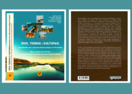 https://amazondamsnetwork.org/wp-content/uploads/2020/12/destaque-ebook.jpg
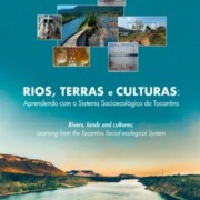
430
1500
Simone Athayde
https://amazondamsnetwork.org/wp-content/uploads/2021/02/ADN__logo_100pxvert.jpg
Simone Athayde2020-12-16 18:51:152021-05-11 15:02:44E-book: Rios, Terras e Culturas: aprendendo com o sistema socioecológico do Tocantins
https://amazondamsnetwork.org/wp-content/uploads/2020/12/destaque-ebook.jpg
430
1500
Simone Athayde
https://amazondamsnetwork.org/wp-content/uploads/2021/02/ADN__logo_100pxvert.jpg
Simone Athayde2020-12-16 18:51:152021-05-11 15:02:44E-book: Rios, Terras e Culturas: aprendendo com o sistema socioecológico do Tocantins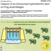
New paper: Impacts of an Amazonian hydroelectric dam on frog assemblages
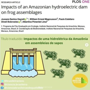
Authors: Jussara Santos Dayrell, William Ernest Magnusson, Paulo Estefano Dineli Bobrowiec, Albertina Pimentel Lima
Citation: Dayrell JS, Magnusson WE, Bobrowiec PED, Lima AP (2021) Impacts of an Amazonian hydroelectric dam on frog assemblages. PLoS ONE 16(6): e0244580. https://doi.org/10.1371/journal.pone.0244580
Pesquisadores do Instituto Nacional de Pesquisas da Amazônia (INPA) realizaram uma pesquisa pioneira na avaliação de longo prazo dos impactos de uma mega hidrelétrica, localizada na Amazônia brasileira, sobre as comunidades de sapos. Jussara Dayrell enviou o texto abaixo sobre artigo, o primeiro derivado de sua tese de doutorado:
.
“Os levantamentos de fauna associados às avaliações de impacto ambiental da hidrelétrica de Santo Antônio (Rondônia) estão entre os mais intensivos, bem planejados e de longo prazo já realizados no Brasil. É uma hidrelétrica com turbinas do tipo bulbo que requerem menos água e produzem um reservatório de tamanho reduzido (271 km2). Foi usada a base de dados do Monitoramento da Herpetofauna, compilado entre 2010 e 2017. Os dados foram coletados 2 anos antes, em áreas posteriormente inundadas pela hidrelétrica (estágio pré-inundado) e não inundadas (pré-não inundado), com intervalos logo após o enchimento (pós 1) e 2 anos depois do enchimento (pós 2).
.
Registramos 96 espécies de sapos. O enchimento da barragem da hidrelétrica teve pouco efeito no número de espécies. A composição de sapos nas áreas permanentemente inundadas pelo barramento do rio não se restabeleceu nas áreas remanescentes e 6% das espécies não foram mais registradas. As hidrelétricas de Santo Antônio e Jirau inundaram 118 km² de floresta de várzea. Com isso, nossos resultados mostram a necessidade de proteção das florestas de várzea afetadas por barramentos de hidrelétricas.
.
Nas áreas não inundadas, também houve mudanças na composição de espécies ao longo do tempo, com o ganho de espécies em 82% das parcelas amostradas, principalmente naquelas localizadas próximas da nova margem do rio Madeira. Esse aumento no número de espécies nas áreas remanescentes pode ser uma resposta à inundação das áreas baixas, pois, após o enchimento do reservatório, os sapos podem ter se deslocado às áreas mais próximas, aumentando o número de espécies registradas. Isso ocorre no período de reestruturação da comunidade após uma perturbação, onde algumas populações podem diminuir enquanto outras ocupam os novos ambientes.”
.
Para ler o artigo: https://doi.org/10.1371/journal.pone.0244580
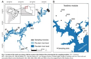
ABSTRACT
About 90% of the Amazon’s energy potential remains unexploited, with many large hydroelectric dams yet to be built, so it is important to understand how terrestrial vertebrates are affected by reservoir formation and habitat loss. We investigated the influence of the construction of the Santo Antônio Hydroelectric dam on the Madeira River in southwestern Amazonia on the structure of frog assemblages based on samples collected in two years before the dam flooded (pre-stage) and one (post1-stage) and four years (post2-stage) after its construction. We surveyed five 500-ha plot systems three times during each stage; in the pre-stage we sampled 19 plots in low-lying areas that would be flooded by the dam, (from now called flooded pre-stage plots) and 45 plots in terra-firme forest (from now called unflooded pre-stage plots). At the post1-stage we sampled the 45 unflooded plots and in the post2-stage we sampled the remaining 39 unflooded plots. We detected frogs by active visual and acoustic searches standardized by both time and sampling area. Few species recorded in the pre-stage flooded plots were not found in the pre-stage unflooded plots or in stages after flooding. However, the composition of frog assemblages based on relative densities in flooded pre-stage plots did not re-establish in plots on the new river margins. In unflooded areas, frog assemblages were distinct among the flooding stages with no tendency to return to the original assemblage compositions even four years after the dam was filled. For the areas that were not flooded, there was an increase in species richness in 82% of the plots between the surveys before dam construction and the first surveys after dam completion, and 65% between the pre-stage and surveys four years after dam completion. Lack of understanding by the controlling authorities of the long-term effects of landscape changes, such as water-table rises, means that studies covering appropriate periods post construction are not required in legislation, but the data from Santo Antônio indicate that changes due to dam construction are either long-term or difficult to distinguish from natural fluctuations. Future environmental-impact studies should follow strict BACI designs.
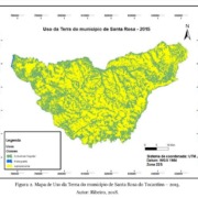
ANALYSIS OF LAND USE AND LOSS OF BIODIVERSITY IN THE MUNICIPALITY OF SANTA ROSA DO TOCANTINS, TOCANTINS STATE, BRAZIL
Chapter 4.1.4: ANÁLISE DO USO DA TERRA E A PERDA DE BIODIVERSIDADE NO MUNICÍPIO DE SANTA ROSA DO TOCANTINS, ESTADO TOCANTINS, BRASIL
Na seção 4, no capítulo 4.1.4 deste livro, trata da análise do Uso da Terra com ênfase na perda da Biodiversidade do município de Santa Rosa do Tocantins, Estado do Tocantins, Brasil, tendo como base as alterações que estão ocorrendo na cobertura vegetal. Na pesquisa foi utilizado as técnicas de Sensoriamento Remoto com a utilização da imagem do satélite Landsat 8, sensor OLI, ano de 2015, resolução espacial de 30m, obtidas gratuitamente via site do USGS. De modo geral os resultados demonstram um grande avanço do uso agropecuário que interferiu, de forma direta, na perda e descaracterização da vegetação natural de Cerrado predominante no município.
Para ler o texto completo acesse o link: https://www.editorafi.org/19rios
Ressaltamos que nesta seção os textos foram publicados no idioma dos autores, na forma de resumo expandido das pesquisas.
*********
ANALYSIS OF LAND USE AND LOSS OF BIODIVERSITY IN THE MUNICIPALITY OF SANTA ROSA DO TOCANTINS, TOCANTINS STATE, BRAZIL
In section 4, in the chapter 4.1.4 of this book, it deals with the analysis of Land Use with emphasis on the loss of Biodiversity in the municipality of Santa Rosa do Tocantins, State of Tocantins, Brazil, based on the changes that are occurring in the vegetation coverage. In the research, Remote Sensing techniques were used with the use of the Landsat 8 satellite image, OLI sensor, during the year 2015, using spatial resolution of 30m, that were obtained free of charge via the USGS website. In general, the results demonstrate a great increase in agricultural use that directly contributed to the loss and decharacterization of the natural Cerrado vegetation that predominates in the municipality.
To read the full text, access the link: https://www.editorafi.org/19rios
We emphasize that in this section the texts were published in the language of the authors, in the form of an expanded summary of the research.
VARIATION IN ENVIRONMENTAL IMPACTS FROM TRANSMISSION LINES ACROSS STATES IN THE BRAZILIAN AMAZON
Chapter 4.1.3: VARIAÇÃO DE IMPACTOS AMBIENTAIS ATRAVÉS DE LINHAS DE TRANSMISSÃO NOS ESTADOS DA AMAZÔNIA BRASILEIRA
Na seção 4, no capítulo 4.1.3 deste livro, o artigo aponta os impactos ambientais causados por linhas de transmissão de energia, implantados na região amazônica brasileira. O Artigo destaca que esses impactos causados não são realmente dimensionados, e causam extensas áreas de desmatamento. Estima-se que rede atual impacta 23.467 km2 de área de terra diretamente e outros 224.588 km2 indiretamente. Sendo que até 2026, estima-se que aumentará em 37% essa área atingida na região amazônica.
Para ler o texto completo acesse o link: https://www.editorafi.org/19rios
Ressaltamos que nesta seção os textos foram publicados no idioma dos autores, na forma de resumo expandido das pesquisas.
*********
VARIATION IN ENVIRONMENTAL IMPACTS FROM TRANSMISSION LINES ACROSS STATES IN THE BRAZILIAN AMAZON
In section 4, Chapter 4.1.3 of this ebook, the article describes the environmental impacts caused by power transmission lines implemented in the Brazilian Amazon region. The Article highlights that these impacts are not really scaled up, and cause extensive areas of deforestation. It is estimated that the current network impacts 23,467 km^2 of land area directly and another 224,588 km^2 indirectly. It is estimated that this affected area in the Amazon region will increase by 37% by the year 2026.
To read the full text, access the link: https://www.editorafi.org/19rios
We emphasize that in this section the texts were published in the language of the authors, in the form of an expanded summary of the research.